From January to the end of August 1942, German U-boats attacked more than 285 vessels in North American waters. Just off coastal North Carolina, the remnants of many of these ships are scattered on the ocean floor. The remains of this little-known battlefield serve as the final resting place for 90 ships and nearly 1,700 men lost during the Battle of the Atlantic. Over the course of the battle, eight Allied convoy vessels, 78 merchant freighters and tankers and four German U-boats sank off North Carolina’s coast. Each shipwreck tells a unique story; today we visit the F.W. Abrams.
F.W. Abrams Sinks


When U-boats first came to the U.S. in January 1942, there were not enough military resources available to institute a full convoy system for merchant ships. The U.S. Navy had to come up with a solution. They determined vessels were only to travel during daylight hours and find safe harbor at night in coastal ports. However, in some coastal areas there were no deep-water ports that ships could reach in a single day. To remedy the situation, the Navy fashioned a series of anchorages from anti-submarine netting and mines. One of the anchorage areas was southwest of Diamond Shoals, North Carolina.
On June 10, 1942, F.W. Abrams was traveling from Aruba to New York, carrying 90,000 barrels of oil. As the tanker reached North Carolina’s coast that evening, a U.S. Coast Guard patrol vessel escorted it into the protected Diamond Shoals anchorage area. The ship stayed there for the night, and at first light, it prepared to get underway. At 5:45 a.m., the Coast Guard began to guide F.W. Abrams out of the danger area.
As F.W. Abrams followed the patrol vessel out of the minefield, the dreary morning’s weather worsened. Fog, rain, and rough seas caused the ships to lose visual contact. F.W. Abrams proceeded, while the patrol vessel searched for the tanker in vain. After about an hour, F.W. Abrams’s captain thought he was out of the danger area, but he was wrong.
At 6:40 am, an explosion rocked the tanker’s starboard bow. The tanker attempted to retreat to a nearby port, but at about 7:20 am, another explosion violently struck the ship. One crew member thought he saw a submarine on the port side, and the tanker’s crew believed they were under attack by a U-boat. Twenty minutes later, a third and final explosion tore through the port side of the tanker, and the captain gave the order to abandon ship.
Meanwhile, the Coast Guard patrol boat attempted to stay in contact with F.W. Abrams, but being unable to find the ship after a couple of hours, it returned to port. F.W. Abrams’s crew safely made the short trip to Ocracoke Naval Station with all 36 men arriving by 12:40 pm. Several days later, the wreck site was observed, and it was clear that the remains of F.W. Abrams were no longer salvageable. The ship had settled bow-first into the sandy bottom with only the masts visible.
Review of the incident, including the location of the vessel as it strayed from its escort in foul weather, convinced Fifth Naval District officers that F.W. Abrams had, in fact, strayed into the minefield. Contrary to its intended purpose to protect against German U-boats, the minefield claimed a casualty.
Resting in just 70 feet (21 m) of water, F.W. Abrams’s masts were visible for years after it sank, and the wreck was considered a navigational hazard. Pilots in training at nearby Cherry Point Marine Corps Air Station used the masts as bombing targets, and in 1944, the Navy Salvage Service formally demolished F.W. Abrams to give ships better clearance.
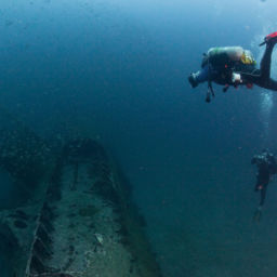
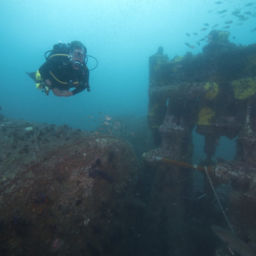
Diving F.W. Abrams


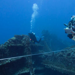
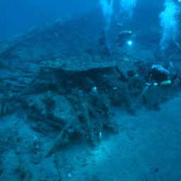
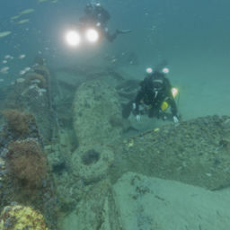
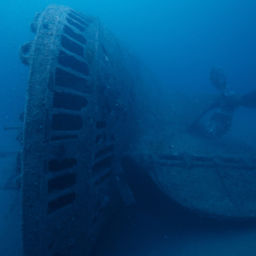
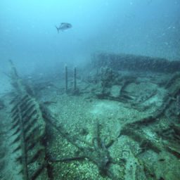
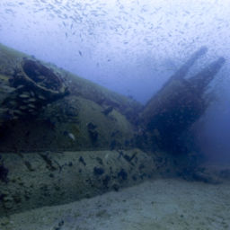
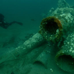
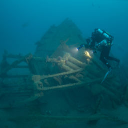
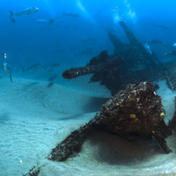
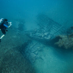
As a result of the shallow depth, moderate relief, and overall size, F.W. Abrams is a popular dive site. The ship still rests in about 70 feet (21 m) of water, sitting upright on a flat, sandy bottom. The tanker is broken in two amidships with a distinct separation of the bow and stern sections. The bow is less intact, which is consistent with the damage caused by the mine strikes. Within a small debris field to the west, north, and south of the main bow area the stem post remains intact.
The tanker’s port side is more complete, extending several feet off the bottom. Much of the tanker’s machinery is still present, including three scotch boilers and associated steam equipment. The engine pistons are evident, but the structure surrounding them is gone. Like at the bow, a small area of debris radiates a short distance from the stern section.
F.W. Abrams is home to an abundance of marine life. The wreck structure offers a haven for fish, sea turtles, corals, mantas, and many other marine creatures.
In 2016, a group of avocational divers with the Battle of the Atlantic Research and Expedition Group (BAREG) helped document and map the F.W. Abrams site. After taking classes and receiving certification through the Nautical Archaeology Society, the group dove on the site over several days. A tropical storm interrupted their survey work, but they returned in 2017 to finish the job.
“F.W. Abrams was the fourth North Carolina wreck BAREG had surveyed for the Monitor National Marine Sanctuary, and it proved the most difficult,” says Bill Chadwell, operations coordinator for BAREG. “Much of the wreck was buried in sand, and the overall orientation of the wreckage, especially at the bow, complicated our understanding of the wreck site at first, but we were able to successfully complete the project the following year.”
BAREG’s efforts provided a wealth of images and video and helped in the completion of detailed site plan and a photogrammetric 3D model of the site.
Although F.W. Abrams is not considered a war grave because all of the crew survived, it is an important piece of our nation’s history as one of the merchant ships that sank during World War II. We encourage divers to leave the wreck and its artifacts intact for future generations.
To learn more about F.W. Abrams and other World War II shipwrecks off the North Carolina coast, click here.
An Expanded Sanctuary
In an effort to honor the service and sacrifice of those lost during the Battle of the Atlantic, NOAA in 2019 will release a draft proposal to expand the boundaries of Monitor National Marine Sanctuary to include a nationally significant collection of shipwrecks that currently have little or no legal protection. The expansion would also establish the largest area designated as a World War II battlefield anywhere in the world. F.W. Abrams is one vessel included in the proposal.
To learn more about the proposal, click here.