From January to the end of August 1942, German U-boats attacked more than 285 vessels in North American waters. Just off coastal North Carolina, the remnants of many of these ships are scattered on the ocean floor. The remains of this little-known battlefield serve as the final resting place for 90 ships and nearly 1,700 men lost during the Battle of the Atlantic. Over the course of the battle, eight Allied convoy vessels, 78 merchant freighters and tankers and four German U-boats sank off North Carolina’s coast. Each shipwreck tells a unique story; today we visit the E.M. Clark.
E.M. Clark sinks


During World War II, E.M. Clark was part of a larger transportation network that carried petroleum products to support the Allied war effort both at home and abroad. Standard Oil Company of New Jersey owned the ship, which made 41 voyages from 1939 to 1941, carrying over 4 million barrels of petroleum products. In 1942, E.M. Clark completed two trips, but its third trip for the year would it be its last.
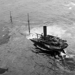
On March 11, 1942, E.M. Clark left Baton Rouge, Louisiana carrying 118,000 barrels of heating oil destined for New York. As darkness fell the evening of March 17, the ship encountered rough seas and lightning as it approached the Diamond Shoals Light Buoy. Around 1:00 am, U-124, lurking just southwest of the buoy, spotted E.M. Clark traveling alone. Using the squally weather conditions, U-124 moved close to E.M. Clark and fired one torpedo that tore into the tanker’s port side four feet below the waterline.
The exploding torpedo buckled the deck and brought down the foremast and radio equipment. While the crew attempted to rig an emergency radio distress signal, another torpedo ripped through the stricken vessel at the bow. The ship was fatally wounded and sank in just 10 minutes.
By the time E.M. Clark was bow down in the water, the sea was covered in oil, making the men in the lifeboats sick from the fumes. U-124 surfaced and for about an hour and a half circled E.M. Clark and its lifeboats. The submarine was last seen at 3:00 a.m. heading northwest looking for another target. Of the 41-man crew, 40 survived and were rescued. The USS Dickerson rescued 14 survivors and the Venezuelan tanker Catatumbo rescued the other 26.
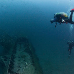
Diving the E.M. Clark


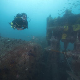
Resting on its port side in about 240 feet (73 m) of water, E.M. Clark is completely intact from bow to stern. It is one of the best representations of a World War II merchant ship off the North Carolina coast. Although the depth of the shipwreck will prohibit all but the most experienced technical divers from exploring the site, E.M. Clark nonetheless offers the technical diver a unique dive experience on a very well-preserved shipwreck.
“Visibility at the wreck site is stunning,” says Tane Casserley, Monitor National Marine Sanctuary’s research coordinator and NOAA diver.
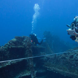
“When you start at the bow, the prevailing current helps you to glide along the wreck, allowing you to truly experience the wreck and all the marine life. As you move toward the stern, the wreck begins to disappear behind you. Then you come to the fantail, which is beautiful. To me, the architecture of that section looks like the Statue of Liberty’s crown and offers a vivid reminder of why World War II was fought and why we work so hard to protect these shipwrecks.”
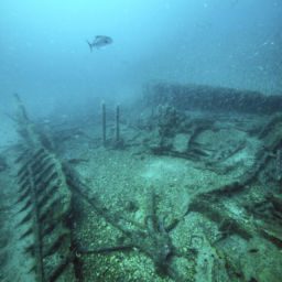
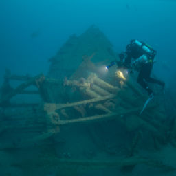
The site of E.M. Clark measures 499 feet long (152 m) and the site’s main feature is the steel hull, which lies mostly intact on its port side. The hull’s exterior steel plates are in excellent condition with only small areas of deterioration. The wreck’s highest point is the starboard side main deck, which sits at least 50 feet (15 m) off the seafloor.
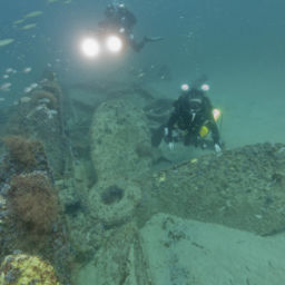
The bow’s starboard anchor is in place and visible in the hawse pipe. The port-side anchor is buried in the sand under the vessel. Both anchor chains run up through the hawse pipes to the deck, where they wrap over the windlass and continue down into the chain locker. The deck plating in the bow has deteriorated, exposing beams and cross bracing. Additionally, there are large holes in the top of the main deck that allow access to interior compartments.
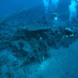
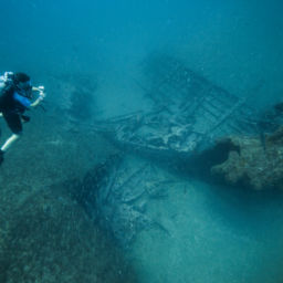
Moving aft, the bridge structure has fallen to the seafloor. Only the outline of where the bridge met the deck indicates where the superstructure once sat. The bridge and all of the associated components, including stateroom and pilothouse materials and portholes, are scattered on the seafloor in a large pile. The main deck planking in this area has also eroded away, exposing the interior of the empty cargo tanks.
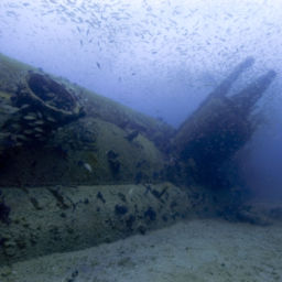
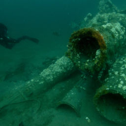
All three of E.M. Clark’s masts have fallen over and lie on the seafloor. The skylight that sat above the engine room is gone, resulting in a large opening 20 feet (6 m) wide. The large, single rudder and two propellers and shafts are intact. The entire starboard propeller remains visible, but only half of the port side propeller protrudes from the sand.
Marine life on the E.M. Clark
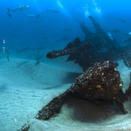
Lying near the western margin of the Gulf Stream, the warm water and the remains of E.M. Clark make the perfect home for an ecosystem teeming with life. The artificial reef supports encrusting invertebrates and a wide variety of fish and sharks. This, coupled with the site’s historic significance, make this a popular spot for technical divers looking for an intact World War II shipwreck.
As with other World War II shipwrecks, E.M. Clark is a war grave. Visitors should not disturb the site, leaving the wreck and its artifacts in place for future generations.
In July 2013, NOAA’s Office of National Marine Sanctuaries nominated E.M. Clark for listing on the National Register of Historic Places and it was accepted. To learn more about the E.M. Clark and other World War II shipwrecks off the North Carolina coast, click here.
An expanded sanctuary
In an effort to honor the service and sacrifice of those lost during the Battle of the Atlantic, NOAA in 2019 will release a draft proposal to expand the boundaries of Monitor National Marine Sanctuary to include a nationally significant collection of shipwrecks that currently have little or no legal protection. The expansion would also establish the largest area designated as a World War II battlefield anywhere in the world.
To learn more about the proposal, click here.